La Costera
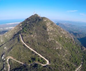
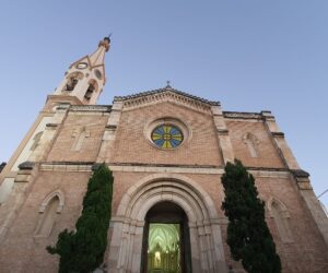
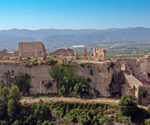
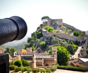
Its capital is the city of Xàtiva, the birthplace of figures such as the painter José Ribera, El Españoleto and Pope Alexander VI. The influence of the Borgia family is felt throughout the city, as is that of Felipe V, who burned Xàtiva in 1707 due to its resistance to his siege. As a memorial to this outrage, the local art gallery still hangs a portrait of the monarch upside down. In its old town it stands the Old Hospital (15th century), the Collegiate Basilica of Santa María La Seu (16th century), the Royal Monastery of Santa Clara, stately palaces such as Alarcón, the museums of l’Almodí and the parish of La Seu, etc. But the first thing the visitor sees when approaching the city is its magnificent castle. The fortress brings together Iberian, Roman, Islamic and Gothic architecture. Entering through the valley of the Cányoles River, the visitor arrives at Canals, with its great Tower, birthplace of Pope Alexander VI; Montesa with its Templar castle and its important Parish Museum; Vallada, with its natural environment, of which the Penyó, Salaella and the Sumidors Tunnel and its Recreational Area of les Ermites stand out, its crafts and the Parish Church; and Moixent, with its impressive landscapes such as Bosquet, and possibly the most important Iberian town in the Province: la Bastida de les Alcusses.
Municipalities
-
Barx
–
-
Barxeta
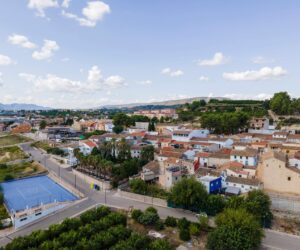
The village of Barxeta is situated in the administrative region of La Costera on the natural route connecting the city of Xativa with the valley of Valldigna and the sea. It is a mainly agricultural town. Mention may also be made of the marble and granite quarries.
-

Canals
Canals is a municipality located in the administrative region of La Costera. Its municipality is 160 m above sea level, sheltered by the Serra Grossa range. In addition to its urban centre, Canals has other centres, such as the neighbourhood of “La Torreta”, and the hamlets of “Aiacor” and “La Torre dels Frares”.
-

Cerdà
The village of Cerdà forms part of the municipalities that make up the administrative region of “La Costera”, approximately 4 km from Xàtiva and 2 km from Canals and L’Alcúdia de Crespins. During recent years, the village has increased in size, probably as a result of its proximity to and good communications with the above-mentioned municipalities. It currently has around 310 inhabitants. It is 60 km from Valencia.
-
Estubeny
The municipality of Estubeny has a population of approximately 129 inhabitants. It is located 64 km from Valencia, at an average altitude of 185 m above sea level. Its main economic activity is agriculture.
-
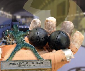
Genovés
–
-
L´Alcudia de Crespins
L’Alcúdia de Crespins is located on the left bank of the River Cáñoles at the entrance to the Montesa valley, facing the mountains of Vernissa. It has a population of approximately 5000 inhabitants and is located at an altitude of 103m above sea level. It lies 10 km from Xativa, the capital of the administrative region, and 61 km from Valencia.
-
La Font de la Figuera
La Font de la Figuera is located at the head of Valle de Montesa, west of the Serra Grossa range. It is located at an average altitude of 553 m above sea level and lies 94.5 km from Valencia and 45.2 km from Xativa, the capital of the administrative region.
-
La Granja de la Costera
The village is located in the administrative region of La Costera in the centre of natural plain that has no outstanding geographical features. It has an approximate population of 350 inhabitants. It lies 4.6 km from Xativa, the capital of La Costera, and 55.7 km from Valencia. Its average altitude is 98m above the sea.
-

La Llosa de Ranes
The municipality is located at the foot of the southern face of Santa Ana. It is situated at an altitude of 109m above the sea. Its highest point is “Greu de la Saliva”, upon which the Hermitage of Saint Anne is located. The village sits at the foot of a hill, and as such some of its streets are very steep. It has a population of about 3,700 inhabitants, and lies 4.4 km from Xativa, capital of the administrative region, and 54.8 km from Valencia.
-
Llanera de Ranes
It is located in the foothills of the Sierra de Enguera range, on the left bank of the River Cáñoles, at a distance of 7km of Xativa, capital of the administrative region, and 58km from Valencia. It is situated at an average altitude of 150m above sea level.
-
Moixent
Moixent is situated on the banks of the River Canyoles, at the foot of the Serra Grossa range. It has a population of about 4,700 inhabitants, and lies 29.7km from Xativa, capital of the administrative region, and 74km from Valencia. Its average altitude is 284m above the sea.
-
Montesa
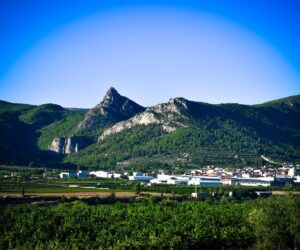
It lies 13 km from Xativa, the capital of the administrative region, and 70 km from Valencia. The River Canyoles runs along the Serra Grossa range. The highest peaks are La Solana (694 m), La Ferradura (676 m) and Tossal dels Polsos (684 m). It has a population of about 1,370 inhabitants and is situated at an altitude of 340m above the sea.
-
Novetlé
Novetlé is located on flatlands on the banks of River Canyoles River and at the foot of the Sierra Vernissa range. It is located at an altitude of 84m above sea level.
-
Rotglà i Corberà
The municipality is located in the northwest of the administrative region of La Costera. It lies 55km from Valencia.
-
Torrella
The area is almost flat and the village is located at an altitude of 135 m above sea level. The only outstanding landforms are “Loma Vella” and the “Hoya” ravine. It lies 6km from Xativa, the capital of the administrative region, and 57km from Valencia. It has a population of approximately 150 inhabitants, and its economy is mainly based on the cultivation and marketing of oranges.
-
Vallada
Vallada is located near the River Canyoles and the Serra Grossa and the Serra de Enguera ranges. Its economy is mainly based on furniture manufacturing. It is located at an altitude of 300m above sea level. It lies 24km from Xativa, the capital of the administrative region, and 75km from Valencia. Its population is approximately 3,400 inhabitants.
-

Vallés
Vallés is a small town in the administrative region of La Costera, located to the left of the River Canyoles. Its relief hardly presents any significant landforms. Its economy is mainly based on agriculture. It lies 5km from Xativa, the capital of the administrative region, and 58km from Valencia. It has an approximate population of 140 inhabitants. It is located at an altitude of 98m above sea level.
-
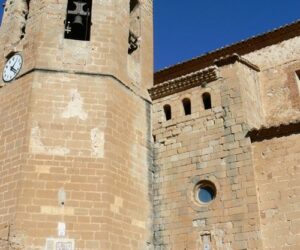
Xàtiva
Xàtiva’s splendid historical and artistic heritage reveals the footprints of the diverse civilizations that have passed through the city in the form of their culture, their monuments and their historical episodes, some of them awash with bloody. A cultural, historical and heritage city, the capital of the administrative region of La Costera, with very important tourist, commercial and industrial sectors and excellent communications by road and rail. It lies 62km from Valencia and 42km from Gandia. Its economy was formerly based on agriculture and industry, although is now specialised in the services sector.

