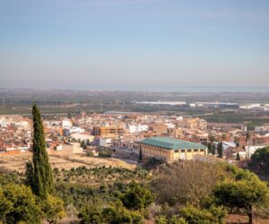
El Camp de Morvedre
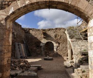
This is the coastal region bordering the Province of Castellón. The beaches of Sagunt and Canet d’en Berenguer are recognised every year for the quality of their waters and services. Sagunt, the capital, deserves a careful visit. This two-thousand-year-old city offers one of the most beautiful monumental areas left by the Romans in Spain. In the castle, a fortress built on a hill, are the remains of the Roman forum. The artistic ensemble is completed with the Jewish quarter, a unique neighbourhood that has maintained its original layout over the centuries, and the Roman theatre, as well as the Churches of El Salvador and Santa María. The inland part of the region boasts Beselga and Font de Barraix, as well as the Arab aqueduct in Estivella, the Sant Esperit Monastery in Gilet, the Medieval Tower of Benavites and the Arab Baths of Torres Torres.
Municipalities
-
Albalat dels Tarongers
–
-
Alfara de la Baronia
Located in the northwest of the administrative region of Camp de Morvedre, in the Palancia River Valley. The river divides the municipality into two halves, with the urban centre to the right. The highest mountains in the municipality are “Picaio” (388 m.), “La Costera” (261 m.) and peak known popularly as “Muntanyeta de l’Hermitage” (229 m.), at the foot of which lies the village. The climate is Mediterranean. The mountainous area of the municipality (365 hectares) is covered with pine forests, which are owned by the municipality; there is thyme, rosemary and some esparto. The village can be reached from Valencia via the A-23, taking the CV-327 after passing through the nearby village of Algimia de Alfara. The vegetation is typically Mediterranean. Both dryland (almond, carob and olive trees) and irrigation (especially oranges of different varieties) farming is carried out in the municipality. Mention may be made of the winter months, during which the orange trees offer their fruit with an explosion of orange hues. Due to the absence of invading forces, the village of Alfara de la Baronia retained its Roman character up to the arrival of the Moors. James I of Aragon conquered the hamlet of Alfara, which came to form part of the Barony of Torres Torres. In 1270, the Barony was gifted to Betrá de Bellpuig, before being passed on to other noble families. The most important was the Vallterra (1445-1760), and the last lords were the Castellví, who held the village until the extinction of the noble estates in 1780.
-
Algar de Palància
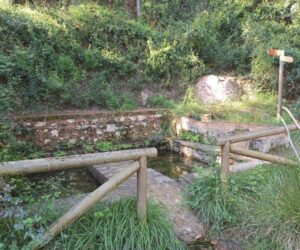
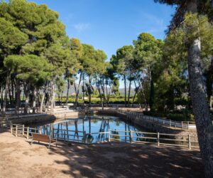
Due to the location of Algar, the municipality is rich in natural landscapes and recreational areas, such as that located in the area known as “Els Planets”, which is equipped with facilities for making paella, stone benches, tables and running water, making it ideal for spending a great day in the country. Another recreational area is to be found at” La Presa de Algar”, offering excellent views over the Algar dam and equipped with a playground and a garden area.
-
Benavites
Thanks to its geographical location within a horseshoe-shaped valley that is open to the sea, this village enjoys special climatic conditions within the western Mediterranean climate. The municipality is completely flat and is drained by two ravines which flow into the marsh. The economy is basically agricultural, to the extent in which orange groves and warehouses cover almost all the land, creating Benavites’ characteristic landscape.
-
Benifairó de les Valls
The village forms part of the administrative sub-region of “Les Valls”, located just 7 km from the Mediterranean coast. It is located on a flat plain, forming a single urban centre with the village of Faura. Its economy is based mainly on agriculture, and is practically dedicated to the monoculture of orange growing.
-
Canet D´En Berenguer
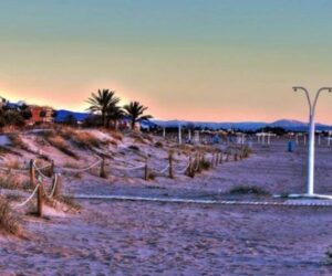
Canet d’En Berenguer offers a contrast of orange groves and seacoast. At the southern end of the coast lies the village’s lighthouse. Measuring 30m in height, it was built 300 m offshore in 1904. The Raco de Mar is a natural beach measuring 80 metres in width, with clear, shallow waters and fine sands. It also has a leisure port and offers excellent conditions for fishing. It is also possible to visit the ethnological museum and appreciate how Canet’s inhabitants dressed, lived and behaved in the past. The 18th-century Gothic church of St. Peter the Apostle is located atop an earlier church built in the 15th-century. Palatial house built between 17th- and 18th-century. Numerous hamlets/farmhouses dating from 13th-century.
-

Estivella
Estivella is located in the administrative region of Camp de Morvedre and has a population of 1,436 inhabitants, although this number increases during the summer. The River Palancia, which flows along the foot of the Sierra Calderona mountain range, runs through the municipality. The 21km² municipality is bounded on the north by Torres Torres; on the east by Sagunto, on the south by Albalat dels Tarongers and Segart; and on the West by Serra. It lies 30km from the city of Valencia. Its economy is based on agriculture, and especially the farming of citrus fruits. Years ago, craft activities such as making hand-woven rugs and bull-horn combs were popular. It currently has a small industrial estate. It forms part of the tourism and leisure sector, and has a camping site focused on rural tourism -the “Camping Sierra Calderona” – and a leisure park, “Estivella pla”, located at the foot of Mount Garbí.
-
Faura
Faura is located 5 km north of Sagunto. It belongs to the sub-region of La Vall de Segó. The surrounding land is replete with orange groves, and is very fertile thanks to the waters obtained from “Font de Quart”. The municipality is divided into districts, such as Almorig, Rubau, el Roll, la Garrofera, Arriba and Abajo, and natural landscapes, such as “les Hores”, “els Llogarets”, “la Rodana”, “el Colander” and “Muro”.
-
Gilet
The municipality is located in the province of Valencia, in the administrative region of Camp de Morvedre, and is also included in the administrative sub-region of La Baronía. It is located on the south-easterly side of Sierra Calderona range, next to the River Palancia basin. The municipality covers an area of some 11.3 km2 and is located 100m above sea level, some 30 Km from Valencia and 6 Km from the town of Sagunto. It lies between mountains yet is also close to the sea. It currently has about 2500 inhabitants, having registered a large increase in the last four years due to its proximity to Valencia and Sagunto and its excellent road connections with both. Within the administrative region of La Baronía, it is the village that has experienced the greatest levels of growth in recent years, as is borne out by the numerous houses that are under construction in the area
-
Petres
Located in the lower valley of the River Palancia, 28 km from Valencia and 2 km from Sagunto. To the north it borders with the mountains of Rodana and Ponera. Its economy is mainly based on irrigated agriculture.
-
Quart de les Valls
Quart de Les Valles is located only 7 km from the coast, in the north of the province of Valencia and bordering with the province of Castellon. It belongs to the sub-region of La Vall de Segó. It has a population around 1,100 inhabitants and its economy has traditionally been based on irrigated agriculture.
-
Quartell
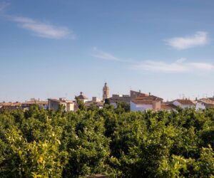
The municipality measures 3.26 km and runs from west to east from the foothills of the Sierra de Espadan range, almost to the coastal wetlands of the Mediterranean shore. It is located in the centre of the so-called “Vall Sego”. The area was used by the Romans who inhabited Sagunto for the construction of summer houses, attracted by the abundant waters originating in “Font de Quart”, the benign climate and harmony of its landscapes. Its agricultural land provides the best strawberries in the country, exceptional muscat grapes, the best oranges in the region and a range of fruit and vegetables that includes melons, watermelons and tomatoes.
-
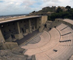
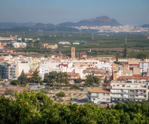
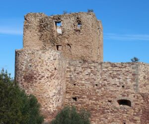
Sagunto
The town has two main centres: the old town or Sagunto-City, located at the foot of the castle and the Roman theatre, and Puerto de Sagunto, 5 km from the historic centre. Through its noble stones, Sagunto relates the history of the majestic, decisive cultures that have existed in the history of the Iberian Peninsula. A stroll through the historic-artistic centre, with its vestiges of past centuries and national monuments, provides a journey through time, given of the importance of the town’s historical and archaeological heritage. The centre of Puerto de Sagunto, one of the last manufacturing towns in Spain, offers us a tour of its past, including the Blast Furnace No. 2, a symbol of its industrial heritage. Our 13 kilometres of coastline offer many options for enjoyment and relaxation, with Blue Flag beaches holding certificates of environmental suitability, accessibility, quality and Q for Qualitur and Q for Tourism Quality flags, mountain trails, local history and a rich cultural offer.
-
Segart
Segart is surrounded by mountains and nestled in the Sierra Calderona mountain range, some 35km from Valencia.
-
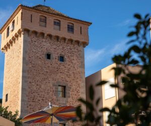
Torres-Torres
Torres Torres is a small, quiet village located in the Valencian administrative region of “Camp de Morvedre” in the Palancia Valley, halfway between Sagunto and Segorbe and only 40 km from the city of Valencia. Its economy is based mainly on agriculture, and above all irrigation farming and orange growing. The hectares of dry land farming are divided between almond, carob and olive trees. The remaining land is hilly with scrub and pines

