El Camp de Túria
This is the territory encompassed by ancient Iberian and Roman Edetania, whose capital, Edeta, is the current Llíria. A city with a great musical tradition, it has an interesting old town. One of the architectural landmarks of the town is the Saint Michaels’s Monastery and the Church of the Blood. Nearby is Benisanó, a town that stands out for its castle and its walled enclosure. The Cartuja de Portaceli in Serra, built between the 13th and 16th centuries, still houses a religious community, and is sited among pine forests, inviting reflection and recollection.
Municipalities
-
Benaguasil
The privileged location of the land around Benaguasil and its municipality, next to the River Turia, the extraordinary fertility of its soil and its delightful climate, have been the decisive factors for which, throughout its history, it has been occupied by the most diverse peoples since ancient times. Throughout its history it has been subject to an interrupted series of invasions of the most diverse forms, both hostile and peaceful, from foreign invaders (Greeks, Phoenicians, Carthaginians, Romans, Visigoths and Muslims), whose cultures were mixed with the native, giving it its own personality.
-
Benissanó
Benisanó, which is surrounded by agricultural land of La Pobla de Vallbona, Benaguasil and Llíria, is located at an altitude of about 250 m above sea level and lies 23 km from the city of Valencia. It is one of the most beautiful towns in the administrative region of Camp del Turia. Benisanó has a large offer in hotels. This is a clear example of the good work of the restorers and of course, of the unique historical environment of Benisano, as well as the hospitality and kindness of its people. The village’s declaration as a tourist municipality by the Valencia Regional Government identifies Benisanó as a tourist destination and a new meeting point for Valencians and tourists alike.
-
Bétera
Bétera has many attractive tourist resources that convert it into, among other things, a Congress Tourism destination. This is especially true given its location near the Valencia Convention Centre and the Valencia Exhibition Centre. Bétera extends to the foot of the Serra Calderona Natural Park, and as such has excellent natural resources that make it apt for the practice of ecotourism. The Route of El Cid (Taifa of Alpuente and Camino de Castilla) is the most important of the routes that exist today. Residential tourism is popular due to the town’s proximity to Valencia and its natural environment, thus making Bétera a great place not only for holidaying, but also for living all year round. The municipality of Bétera, which covers an area of 75.67 km2, belongs to the administrative region of ‘Camp of Turia’, located in the province of Valencia. It is located at an altitude of 120 metres and a distance of 18 kilometres from the capital and 23 kilometres from the sea. The municipality has at present 19,935 inhabitants (Data from Population Census at: February 2007). It is composed of a central urban nucleus, Bétera, and various settlements and residential areas spread throughout the municipality.
-
Casinos
Casinos is located 38 km from Valencia, on the northwest edge of the Llíria plain and on the border with La Serrania. The township’s population is around 3000, and agriculture remains the mainstay of its economy, and most notably grapes, almonds, olives, cereals, oranges and tangerines, as well as the making of handmade sugared almonds and nougat.
-
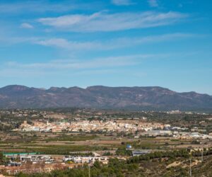
Gátova
The municipality of Gátova, which covers an area of 30.4 square kilometres, is situated on the western edge of the Sierra Calderona range, which descends towards the Mediterranean Sea, to the east of the Cuevasanta and Alcublas mountains and within the anticline initiated by the Sierra de Javalambre range and which continues through the Sierra de Andilla range, together constituting the foothills of the Iberian System. Its entire territory lies within the Sierra Calderona Natural Park. Situated between the provinces of Castellon and Valencia and the administrative regions of Alto Palancia and Camp de Turia, it lies 43 km from Valencia, with access via the Olocau-Gátova-Altura road.
-
L’Eliana
L’Eliana is located in the metropolitan area of Valencia and on the left of the River Turia, 15 km from the city. It has more than 16,500 inhabitants. The municipality is almost completely flat, with some gentle slopes and average altitude of 93m above sea level.
-
La Pobla de Vallbona
La Pobla de Vallbona covers an area of 33 square kilometres. The town is notable for its economic diversification: a good part of the municipality is dedicated to agricultural production, which are accompanied by four industrial estates. There is also significant activity in the construction and services sectors. Located in the Camp del Turia administrative region some 22.6 km from Valencia and approximately 102 m above sea level.
-
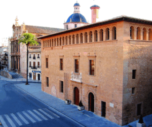
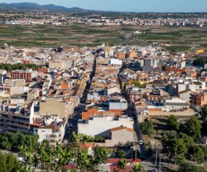
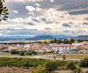
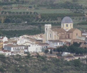
Llíria
Llíria is located in the northwest of the province of Valencia, 25 km from Valencia. It is the capital of the Camp de Túria administrative region. Its municipality (229.82 km2) is one of the largest in the Valencia Region, with a contrasting landscape composed of the mountainous foothills of the Sierra Calderona range and an agricultural area lying on the left bank of the River Turia. It offers an exceptional cultural heritage and, in addition to being a historical town, is steeped in musical tradition, being known as the “City of Music”. It has one of the most significant archaeological and monumental sites of all Valencia. These two characteristics make it a “Symphony of Cultures” for both the inhabitants of Llíria and for its visitors.
-
Loriguilla
Loriguilla is a village of 1200 inhabitants located about 18 km from Valencia. It is well connected by road and rail to all the major cities and communication routes in the Valencia Region. Although historically a farming village, today most of the population works in the service sector and industrial activities. Nevertheless, a large part of the municipality is still dedicated to orange farming.
-
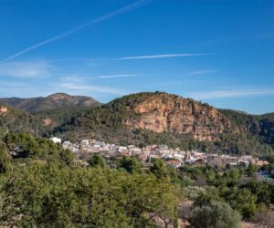
Marines
Marines is a municipality pertaining to the administrative region of Camp de Turia, located in the administrative subregion of Vall d’Olocau. It has about 1,500 inhabitants, and a part of its territory is occupied by the Marines military base. It occupies a large section of the southern slope of the Sierra Calderona range, and is surrounded by the mountains of Gorgo, Rodeno, Castillo Real and Peña Roya. The population is divided into two centres: the old Marines de la Sierra (455 m) and the new Marine del Llano.
-
Náquera
Nàquera is located in the foothills of the Sierra Calderona range, 23 km from Valencia. The municipality is divided into two distinct parts: the plain and the mountains. It is located on a small hill, upon which there was formerly a castle, at an altitude of 212 m above sea level and at the entrance of a large and luminous valley. Surrounded by pine trees and fountains, there are many residential area distributed throughout the municipality. It also has an industrial park located in the southwest of the municipality on the border with the town of Moncada, just metres from the junction with the bypass.
-
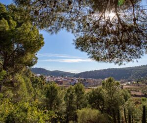
Olocau
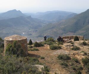
The municipality of Olocau is located in the administrative region of Camp de Túria, in the western foothills of the Sierra Calderona range and to the left of the Carraixet Ravine. It is located at 269 m above sea level and at a distance of 30 km from Valencia, 10 km from Llíria, 15 km from Bétera and 17 km from the nearest Mediterranean motorway junction. Its municipality covers some 36.62 km2 and has a population of 1,647 inhabitants. There are currently more than 300 hectares occupied by residential developments, mainly dedicated to second homes and whose inhabitants take the population in summer up to more than 10,000 inhabitants. By virtue of its excellent geographical location, Olocau is crossed by several hiking routes that are abundant in vegetation, minerals and wildlife. Each route crosses its own, unique landscape, each stone has a history, all of them reveal the presence of man and his works throughout the ages, and all of them can inspire the life of an era.
-
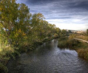
Riba-Roja de Túria
The town sits atop a gently-sloped hill to the right of the River Turia. It has a population of about 20,700 inhabitants and is located 20 km from Valencia, at an altitude of 125 m above sea level.
-
Vilamarxant
Vilamarxant is located on the right bank of the River Turia, 25 km from Valencia. Its location in a transition zone between the plain and the mountains gives rise to a quite hilly terrain. More than half the territory is occupied by mountains. Despite the expansion of industrial activity, agriculture remains the main source of income.

