La Canal de Navarrés
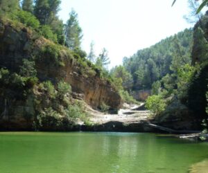
Water has shaped the geography of this region for centuries. Places of great beauty abound, such as the Charcos del Río Grande at its passage through Quesa. The town of Anna is famous for its Albufera, a lake surrounded by poplars, where you can take boat rides; and also for the Gorgos. Facsinating castles, such as the Castle-Palace of the Counts of Cervellón in Anna, or those of Bicorp and Bolbaite, as well as the Iberian sites of Enguera, a town where it is also possible to visit the Church of San Miguel, the parish and archaeological museums or the Carmelite monastery. The cave paintings found in Bicorp and Quesa are part of the group known as Levantine Rock Art, declared a World Heritage Site by UNESCO.
Municipalities
-
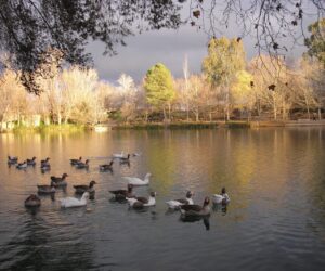
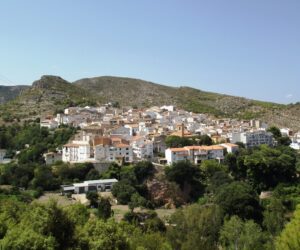
Anna
The name of this municipality is Arabic in origin and means “water”. Visitors are able to appreciate how water has carved capricious forms into the landscape, especially in the area of l’Albufera d’Anna, which is surrounded by poplars and leafy trees which provide welcome shade in the summer. The crystal-clear waters of the pools, such as “la Escala”, “el Català” and “la Font Negra” create an idyllic landscape.
-
Bicorp
Bicorp is to be found in the province of Valencia , within the Canal de Navarrés region , and belongs to the judicial area of Xativa and the judicial zone of d’Enguera. It lies some 98 km from the province’s capital. The municipality covers an area of some 136.66 km 2 and the village is situated at 290 m above sea-level. Bicorp lies between the River d’Escalona and the Caroig Massif. Its limits are: to the north, Cortes de Pallás and Millars; to the east, Quesa; to the west, Teresa de Cofrentes and Ayora; and to the south, Quesa. The landscape within the municipality is highly rugged and rough, crossed by numerous ravines that isolate areas and form mounds. The most significant heights in the area are: Toro ( 893 m ), Mola de Bicorb ( 904 m ), Hongares ( 842 m ), Santís ( 949 m ) and Cazmilla ( 986 m ). The River Cazuma (or Cazumba), which is formed by the union of the Llatoneros and d’Hongares ravines, crosses the municipality from west to east. The village is located at 39°08″ latitude north and 2°54″ latitude east on the Madrid meridian. It is situated on a mound and is almost completely surrounded by the Moreno ravine.
-
Bolbaite
Bolbaite is located in the region of Canal de Navarrés in the south-east of the province of Valencia, some 84 km from the city of Valencia. Located in the River Sallent basin, Bolbaite lies in the centre of the region. The municipality’s terrain is undulating, rising from 250m in the east to 600m in the west. It borders to the north with Navarrés, to the south with Énguera and Xella, with which it also borders to the east, and to the west with Quesa, all of which are villages within the province of Valencia.
-
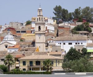
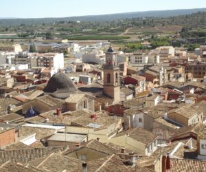
Chella
This municipality is located in the centre of the region. It is mountainous, with a small plain in its centre. The main points of altitude are the 3rd-level triangulation stations of Soterraría (324 m), Monto (417 m) and Gallinero (657 m). The River Sallent crosses the municipality in a south-easterly direction. The municipality is drained by the Turco, Malet, Rafes, Obrer and Brollador ravines, among others.
-
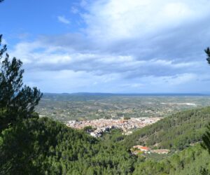
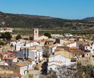
Enguera
Ravines, hills, beautiful mountain landscapes with valuable archaeological treasures and Mediterranean pine and oak forests combine to make Enguera to make a mosaic of incredible landscapes. The spectacular architecture of its historic centre, with its impressive, 17 th century, archpriest church, stately homes, Carmelite convent, squares and streets arranged in the purest Arabic-style, transport the visitor to a variety of different eras. The cheerful, bustling life of the village is in constant contrast to the peacefulness of the surrounding natural wilderness of the Serra d’Énguera mountain range. At times as peaceful and quiet as a dream, at others lively and vivacious, the capital of Valencia’s Canal de Navarrés region is a place that invites you to discover all its secrets and which surprises the visitor with its bustling serenity.
-
Millares
The most notable local monuments include Millares castle, located in the vicinity of the village on the northern slopes of a mountain which runs down onto the River Júcar; the remains of the castle can be seen, together with those of other constructions which formerly stood along the river and which protected the River Júcar’s gorge against possible invasions, including Coves castle, also in ruins, and the lookout tower, which is still standing at a vantage point overlooking the River Júcar. Perched on a slope of Las Cañas ravine, on the left bank of the Júcar, there is a small group of Levantine cave paintings. Dating from a human occupation during either the early days of the metal age or from a little before the end of the Neolithic, the Cova dels Donnes settlement also bears testament to life in the Iberian period.
-
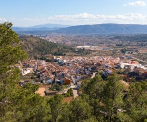
Navarrés
Navarrés, a municipality located in the eastern part of El Caroig, gives its name to the Canal de Navarrés, which is composed of the villages of Anna, Bicorp, Bolbaite, Chella, Enguera, Millares, Navarrés and Quesa. Canal de Navarrés is one of the central administrative regions within the Valencia Region, with Enguera as its capital and Jativa as the nearest large commercial town. Its location places it at the point of access to the mountainous interior of the Valencia province. The municipality covers an area of 47.4 km² and is rectangular in shape. The village itself is located at 298m above sea-level and has the following geographical coordinates: 39° 99’ 50’’ latitude north and 0° 30’ 75’’ longitude east. It borders with Quesa and Tous to the north, with Tous and Sumacàrcer to the east, Chella and Bolbaite to the south and Quesa to the west. It sits on a small plain in a ravine at the base of a hill. The plain is crossed by the crystal waters of the Navarrés River. The old part of the village is filled with small, narrow streets, whilst the newer area has wider, straight roads, including Pintor Tarrasó Avenue. There is also a village named Playamonte within the municipality.
-
Quesa
Quesa is a municipality with some 740 inhabitants, located in the administrative region of Canal de Navarrés and set in the heart of the Caroig Massif at an altitude of 300m above sea level. The municipality, which is large in comparison to the majority of those in the Valencia Region, covers some 7895 hectares, of which 68 are used for irrigation crops, 2884 for dryland farming, 1176 are covered with forests, 2322 are employed for grazing, 834 are unused and only 11 have been built upon. It borders to the north with the municipalities of Millares and Tous, to the south with Navarrés, Ayora and Enguera, to the east with Navarrés, Bolbaite and Tous, and to the west with Bicorp and Ayora.

