La Ribera Alta
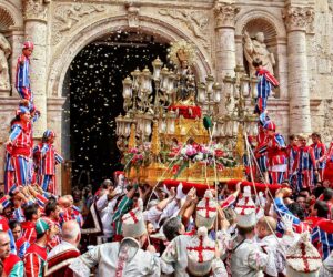
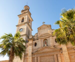
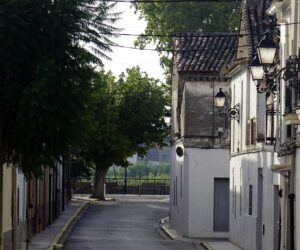
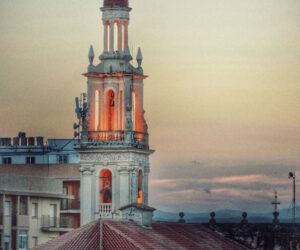
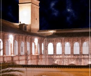
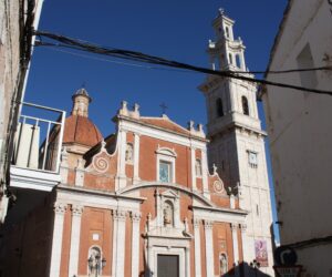
The capital, Alzira, still preserves a large section of the original medieval walls that surrounded the city. This is the most prominent local monument along with the Monastery of La Murta, the Municipal Museum and the City Hall building. Another of the important towns in the region is Carcaixent, cradle of the orange crop, of which monuments such as the Sant Roc de Ternils Shrine and some of the old citrus warehouses are very notable; and Algemesí, with its cultural and folk wealth, of which the Festa a la Mare de Déu de la Salut stands out, with its traditional dances and the popular Muixeranga (Intangible Heritage of Humanity), its Basilica of Sant Jaume (16th century ) and its parish museum.
Municipalities
-
Alberic
The village of Alberic lies in the south of the province of Valencia, in the administrative region of Ribera Alta, between the River Júcar and the Sierra de Tous range, the alluvial plain formed by the River Júcar and the River Verde. The village is located on the left bank of the River Júcar, from which it is separated by a fairly wide area of cultivated land. To the north it borders with the municipalities of Alzira, Massalavés and Benimodo; to the south with Gavarda and Castelló de la Ribera; to the east with Carcaixent and Benimuslem, and to the west with Antella. It lies some 8 km from Alzira, 40 km from the city of Valencia and 55 km from Manises airport. The village has a population of about 11,000 inhabitants.
-
Alcàntera de Xúquer
Alcàntera del Xúquer has a population of about 1,400 inhabitants. It is located on the northern slopes of the Serra Grossa right, on the right bank of the Rivers Júcar and Sellent. It lies adjacent to the village of Càrcer, with it forms a joint urban centre. It lies 48km from the city of Valencia. The municipality is small and mostly flat.
-
Algemesí
Algemesí is located in the Ribera Alta administrative region, on the banks of the Rivers Xúquer and Magre. Part of the municipality belongs to the Albufera Natural Park. With a population of over 28,000 inhabitants, it is the second largest town in the administrative region, second only to Alzira. It lies 5 km from Alzira, the capital of the administrative region, and 32 km from Valencia. Its average altitude is 17 m above the sea.
-
Alginet
Alginet has a total of about 13,000 inhabitants. It is located in the transition zone between Ribera Alta and Huerta de Valencia, from the edge of the Albufera wetlands to the small Falaguera mountain range. The municipality is mostly flat and, due to the high percentage of humidity (very normal in the Ribera administrative region), the perception of heat in the summer often outstrips the actual temperatures indicated by the thermometers. The same phenomenon is produced in winter, during which the sensation of cold is accentuated
-
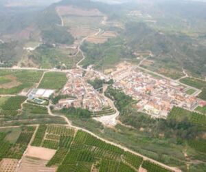
Alzira
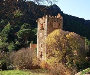
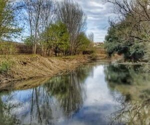
It covers an area of 111.46 square kilometres and, therefore, it is one of the largest in the Valencia Region. It lies 40 km from the capital. The municipality is divided into two sectors: The municipality is completely flat on the banks of the River Júcar. Towards the southeast lie the “Corbera”, “Murta” and “Les Agulles” ranges, which encompass the “Murta”, “Casella” and “Aguas Vivas” valleys. “La Garrofera” sector is broken by the eastern slopes of the “Sierra de Tous” range. The Town Hall (16th century), the medieval walls, the Church of Saint Catherine, the Municipal Museum, the Hermitage of Our Lady of Lluch, as well as numerous natural sites such as “La Casella”, “La Murta” and “El Cavall de Bernat”, as well as Murta Monastery.
-
Antella
Antella is located at the foot of Mount Creuta Alta, between the left bank of the River Júcar and the foothills of the Sierra de Tous range. The terrain is very irregular, with the exception of a narrow strip along the bank of the River Júcar. The main summits are: “Lloma Llarga” (312 m.) and “Moreras” (221 m.). Cantalars and Rodeno. The River Júcar, which crosses the municipality from northeast to southeast, serves as a border with Sumacárcel. In the mountainous areas of the municipality there are scattered pines and pastures.
-
Beneixida
Beneixida is a municipality located in Càrcer Valley in the Ribera Alta administrative region. The land is flat and bathed by the waters of the River Júcar. The highest point is “La Venta del Carbonell”. It has a population of approximately 730 inhabitants and is located at an altitude of 35 m above sea level. It lies 46 km from Valencia.
-
Benifaió
Benifaió has a population of about 12,000 inhabitants. It is located 35m above sea level. Like most Valencian villages, its economic activity has been traditionally linked to farming, an especially the cultivation of oranges. It has recently experimented a growth in the secondary sector due to the village’s proximity to industrial estates and factories, as well as in the service sector due to its proximity to Valencia.
-
Benimodo
A municipality located 34km from Valencia. The terrain is mostly flat. There is a slightly hilly area to the west, in the vicinity of the Serra del Cavallo range. It lies at an altitude of 41m above sea level. It has traditionally been dedicated to agriculture, although there is a growing importance of industrial activity due to the existence of industrial estates near to the village.
-
Benimuslem
Benimuslem is situated on the left bank of the River Júcar. The municipality is completely flat. The River Júcar serves as a limit to the S and SE. The climate is Mediterranean. The most frequent winds blow from the east and from the west: the latter is responsible for bringing rain, usually in spring and autumn. The land is dedicated to irrigation farming. Irrigation water is supplied from the River Júcar, via the Royal River Júcar Irrigation Canal. The most important crops are citrus fruits, wheat, rice and vegetables. The village is situated on the left bank of the River Júcar. The parish church is dedicated to the Immaculate Conception.
-
Carcaixent
The municipality is located between the right bank of the River Júcar, the “Aguas Vivas” Valley and “El Convento” mountains. The municipality is mostly flat and covers an area that forms the Júcar Valley which, once past the village, becomes more mountainous, with the presence of the “Corbera” and “Las Agujas” ranges.
-

Càrcer
The municipality of Cárcer has a population of about 2,000 inhabitants. Its lands are watered by the River Júcar to the north and by the River Sellent to the west. Its economy is based on agriculture, especially the cultivation and commercialization of oranges. Due to urban development, the centre of Càrcer is attached to the neighbouring municipality, Alcántara of Júcar, forming a joint conurbation of approximately 3,400 inhabitants.
-
Carlet
The centre has buildings of different styles, such as Arabic, modernist and Baroque, and also has large agricultural areas in which different varieties of fruit are grown, a large industrial zone and green spaces. It lies at an average altitude of 40m above sea level and is located 30 m to the south of the city of Valencia. The municipality is crossed from north to south by the River Magro, which carries little volume.
-
Catadau
Catadau is located in Vall dels Alcalans, on the west bank of the River Magro. The municipality is relatively flat, with the exception of the southwest sectors, where the Matamón hills lie, and the west, towards the Sierra del Caballón (La Colaita) range, where the highest peaks in the municipality are located in “Alto de los Cuchillos” (760 metres). It lies 32 km from Valencia, at an altitude of 94 m above sea level. It has a population of around 2,700 inhabitants.
-
Cotes
The municipality of Cotes is nestled in the Cárcer valley. Half of the area is almost flat, although there is a mountainous area to the west, in the foothills of mount Montot (419 m). The centre is relatively flat and lies in the northeast of the municipality, next to the River Sellent. Irrigated crops, such as citrus fruits, are the backbone of the economy. It lies 14 km from Alzira and 51 km from Valencia, and has a population of about 400 inhabitants.
-
Gavarda
Gavarda is located on the banks of the River Júcar, in the south-west of the Ribera Alta administrative region. The river and the Royal River Júcar Irrigation Canal surround the village, which has approximately 1,100 inhabitants. It is currently divided into 3 centres: the village centre, the new village (constructed following the floods of 1982), and the Villariezo neighbourhood. It lies 50 km from Valencia and 30 km from the Mediterranean Sea. The area is flat, except in the north and northwest areas, which are mountainous, with maximum heights of 150m. Its average altitude is 85 m above the sea.
-
Guadassuar
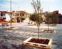
A municipality located in the Ribera administrative region, between the Rivers Júcar and Magro. The municipality is flat and only rises its southern part, where we find “La Garrofera” mountain. The soil is clayey, formed by sediment left by the floods caused by the Rivers Júcar and Magro. The cultivated land is almost completely dedicated to irrigation crops, using water obtained from the Royal River Júcar Irrigation Canal and from wells. It is used for growing oranges and other fruit, such as apricots, plums and peaches, as well as vegetables, peanuts, wheat and corn. The scarce dryland is dedicated to the cultivation of vines, carobs, almonds and olives. Sheep and cattle farming are traditional, as is the rearing of animals for domestic purposes. The village is situated on a plain, and has wide streets and a modern layout.
-
L’Alcúdia
L’Alcúdia is a municipality located in the centre of the Ribera Alta administrative region. The town is located in the eastern part of the municipality. To the north is the River Magro, and to the south the River Júcar Royal Irrigation Canal. It lies 60 km from Valencia and 8 km from Alzira, the capital of the administrative region.
-

L’Ènova
A municipality located in the Ribera Alta administrative region, just 7 km from Xativa. The municipality is flat, with the exception of southern zone, where we find the gentle undulations of “Lloma del Baladre”; Cabezo” and “Monte Valiente”. There is a predomination of irrigation crops, although there are drylands which are used for the production of olives and almonds. The village is situated at the foot of the mountain.
-
La Pobla Llarga
Its population is approximately 4,450 inhabitants. It lies 45km from Valencia. The River Júcar passes close to village, although it does not enter the municipality. The “Barranc de Barxeta” ravine crosses the municipality from north to south, passing through the village centre. Its economy has traditionally been based on agriculture.
-
Llombai
A municipality located on both sides of the River Magro, between the Caroig massif and the Sierra Falquera range. To the north, the municipality borders with Picassent, Real de Montroi and Montserrat de Alcalá, to the south with Alfarb and Catadau, to the east with Picassent and Alfarb, and to the west with Dos Aigües. It lies 28.8km from Valencia.
-
Manuel
A municipality located in the southern sector of the Ribera Alta administrative region, on the right bank of the River Albaida. The River Albaida crosses the municipality from southeast to northwest, and on its left bank are the hills of “Las Salinas”, whose maximum height barely reaches 109 metres.
-
Massalavés
The municipality of Masalavés is located in the Ribera Alta administrative region, on the left bank of the River Verde, or “dels Ullals”, a tributary of the River Júcar. It sits on a gentle hill at an altitude of 28m above sea level.
-
Monserrat
Founded during the Muslim period, the village is located at the foot of the mountain of Castellet, on a small hill is now known as “l’Era Alta”. This hill gave its name to the village. It consists of an incline with a dip in the strata to the north, and which is cut in half by what appears to be a fault, which is responsible for the name: “serrat” (sawn, cut, in Valencian). The municipality is located in Vall dels Alcalans, in the northern part of the Ribera Alta administrative region. The village’s most important crops are grapes and carobs.
-
Rafelguaraf
Rafelguaraf is situated between the River Albaida and the Sierra de Agulles range. The village of Rafelguaraf has 1887 inhabitants and 520 houses, mostly two- and three-story buildings. There are also small villages in the surroundings, such as Tossalnou (340 inhabitants), Riu-Rau (170 inhabitants) and Berfull (35 inhabitants) There are also certain residential areas in the municipality. The most significant are located in “Pla de Dalt” and “Camino de Barxeta”, and less so those in the “Las Delciias” area.
-
Sellent
Sellent has an approximate population of 400 inhabitants. It is located in the valley of the River Sellent, within the Caroig Massif, to the south-west of the Ribera Alta administrative region. It borders with the administrative region of La Costera. There are two areas, divided by the “l’Horteta” ravine. On the right is the old town, the Arabic origin of which is evident in the distribution of its streets. To the left is the new area, with newly built single-family homes.
-
Senyera
Senyera has a population of about 1,200 inhabitants. It is located on the right bank of the River Albaida, and has suffered various floods throughout its history. The land is completely flat and, with the exception of the village, dedicated to the cultivation of crops. Senyera is no longer a predominantly agricultural village, following the creation of new industries and the construction of a multitude of terraced houses.
-
Serra
Serra is located in the heart of the Sierra Calderona range. Its terrain is rugged and its streets steep. Throughout its history, this mountain valley and pass has served as a busy route for pedestrians, travellers, post and even armies pertaining to the different cultures that have populated the Valencia Region.
-
Sumacàrcer
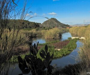
Sumacàrcer is located in the extreme southeast of the Ribera Alta administrative region. During its passage through the municipality, the River Júcar carries its maximum volume, bringing life, wealth and great variety of landscapes. Thanks to the waters of the River Júcar, Sumacàrcer has traditionally been a village dedicated to agriculture. The village sits on a terrace around the river, nestled on the mountainside. It lies 55 km from Valencia and has a population of about 1,700 inhabitants.
-
Tous
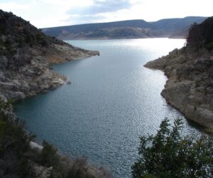
The municipality of Tous is mostly known for its reservoir on the River Júcar, which collapsed in the flood of 1982. In 1979, the village was moved to its current location due to the construction of the Tous dam. It lies 14 km from Alzira, the capital of the administrative region, and 50 km from Valencia. Its population is approximately 1,200 inhabitants.
-
Turis
A municipality belonging to the Ribera Alta administrative region. The terrain is undulating with a few slopes and hills. It has a population of about 6,500 inhabitants and is located 34 km from Valencia. Its economy is mainly based on agriculture.
-
Villanueva de Castellón
Villanueva de Castellon is located at the confluence of the Rivers Júcar and Albaida. The relief is completely flat. Exceptions include Cárcer Port (Serreta de Uchera), and the Castle Mount, upon which lie the remains of the castle that gave name to the village. The rest of the municipality lies at an average altitude of 30-40 metres above sea level. It has a population of about 7,690 inhabitants and lies 48.6 km from Valencia.

