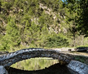
La Serranía
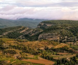
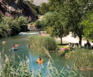
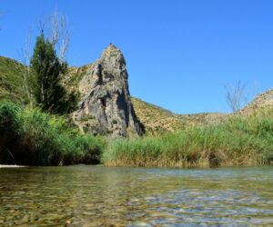
This is one of the steepest regions in the Province. Crossed by the River Turia, it is striking for its rocky cliffs. The Benagéber reservoir is ideal for water sports, and there are also vast pine woods and mountains which are perfect for hiking. The clarity of the night air in Aras de los Olmos makes it a sought-after place for stargazing. It also has a rich artistic heritage. The old towns of Alpuente (with its walled area, the ancient Kingdom of Tayfa, which even minted its own money), Chulilla and Chelva (where it is possible to walk through the Jewish and Moorish quarters known as Benacacira), magnificent Castles like that of Chulilla, and striking monuments such as the Roman aqueduct of Peña Cortada, in Calles.
Municipalities
-
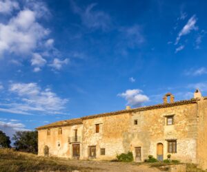
Alcublas
Alcublas is located 50 kilometres to the northwest of Valencia. Most of the municipality is mountainous, although there are also areas dedicated to dryland crops, such as almonds and grapes. The village has a rich architectural heritage, as demonstrated by its buildings, mills, hermitages, ice houses, etc. Its social heritage is represented by its rich cuisine and its festivities. The name of Alcublas is Arabic and means “popular administration”, indicating that the village originally consisted of several groups of hamlets. The earliest historical reference to the town is the Royal Charter granted by King James I of Aragon in Lleida, on 10th April, 1257, by virtue of which he ceded the villages to Teresa Gil de Vidaura in the kingdom of Valencia, noting their limits with the municipalities of Liria, Andilla, Bejis, Jérica and Altura.
-
Alpuente
Alpuente is located in the highest part of the La Serrania administrative region, just over an hour from the capital. The village of Alpuente still retains vestiges of its glorious past, housing remains from the Bronze Age, the Iberians, Romans and Arabs. In the 7th century it was incorporated into Al-andalus, and in 1031 it was declared an independent kingdom of Taifas. Such was its economic and political prestige that came to mint its own currency. Alpuente was the capital of a large territory which corresponded to the administrative regions of La Serrania and Rincón de Ademuz, as well as Sinarca and Arcos de las Salinas. It was conquered by El Cid in 1089 and, after being reconquered by James I of Aragon in 1236, Alpuente remained a place of exceptional importance. The Courts of the Kingdom of Valencia gathered in the village in 1319 and 1383. A building of singular beauty in Alpuente is the former mosque, which now houses the Town Hall. It was used for meetings of the Contractual Market and the Arab administration. A magnificent consistorial hall was added in the 16th-century. The best preserved part of the castle is the “Torre de la Veteta”, or keep. The “Los Arcos” medieval aqueduct is located near to the village. It has thirteen arches and was created to supply the village with water and irrigate the local agricultural lands.
-
Andilla
The municipality of Andilla is located 71km from Valencia, in the northwest of the province of Valencia and on the border with Aragon. It is the second largest municipality in the administrative region of La Serranía, which conditioned the appearance of other villages, such as La Pobleta, Osset, Artaj and the Pardanchinos wineries. Numerous archaeological remains testify that Andilla was populated by cultures prior to the Bronze Age. Furthermore, the village had a certain relevance during the Spanish Civil War, as it was on the battlefront from 1938-1939. The historical importance of the Barony of Andilla is reflected in the large number of monuments that have endured throughout its history.
-
Aras de los Olmos
The municipality of Aras is located in the most north-westerly point of the province of Valencia. It is located in the administrative region of Los Serranos at an altitude of 936 metres above sea level. It has a continental climate, with very cold winters and mild summers. The municipality covers an area of 75 km 2 , of which 60% are dedicated forestry exploitation. The rest is dedicated to the production of grapes, almonds and cereals. It lies 98 km from the city of Valencia. The River Turia crosses the municipality from north to south through landscapes of great natural beauty.
-
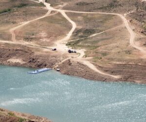
Benagéber
Benagéber is one of the tourist towns in the province of Valencia that conserves a rich and attractive natural and environmental heritage. It is located in the administrative region of La Serranía. Its municipality extends on along a series of mountains and ravines on both sides of the River Turia, and is host to many beautiful landscapes. The majority of the area is covered with pine. The village of Benagéber, which lies next to the old hamlet of Nieva, was built around 1950 with straight streets and whitewashed houses around a square, which houses the Town Hall, the Public School and the Parish Church of the Immaculate Conception, the latter an austere temple that was opened in 1954, very near the municipal swimming pool and sports centre.
-
Bugarra
Bugarra is a town bathed by the waters of the River Turia. This village has become a tourist attraction for those seeking rest and enjoyment in the endless possibilities offered by its waters. It is located on the border of the La Serranía administrative region with Camp de Turia, and is very close to Valencia, which increases its attractiveness. The local economy is based on agriculture (fruit, vegetables, olives and wine). Numerous remains from the ancient settlers from the Bronze, Iberian and Roman periods have been found.
-
Calles
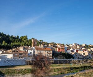
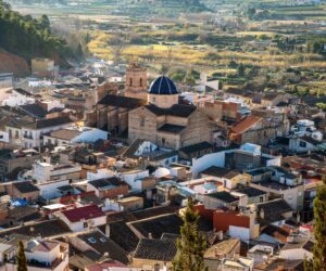
Calles is a picturesque municipality crossed by two rivers: the River Tuéjar, which runs through the village, and the River Turia, or “Blanco”, as it is known in the area, which lies about 4 km from the centre. The municipality has become a wonderful summer destination, with its impressive landscapes and monuments acting as potent tourist attractions. The original centre of Calles, the Barrio de la Petrosa neighbourhood, sits atop a rock that towers over the valley. It is characterized by its twisting streets of Moorish influence, and still retains much of its traditional appearance. At the foot of this neighbourhood is the 17th century Parish Church of the Immaculate Conception, whose façade dominates Plaza de la Iglesia. The old town stretches towards the south. Notable sites in its narrow streets include Plaza del Mesón, where we find the town hall, and Plaza Mayor.
-
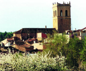
Chelva
Chelva’s centre retains the traces of the peoples who inhabited the area in the past. We are able to enjoy the Muslim quarter of Benacacira, which maintains the hidden, mysterious and secluded air that this culture created in its living spaces. Its narrow streets, the sound of water from its many fountains and its whitewashed houses, evoke a medieval city built on a rock and surrounded by walls to ensure its defence.
-
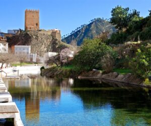
Chulilla
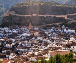
Chulilla is a very beautiful mountain village, located some 60 km from the city of Valencia. The original settlement dates from the first millennium BC. The Castle Hill is the original nucleus of the village. The walls of the ancient fortress, Chullila’s most characteristic and important monument, are still conserved. It was from this point that the village extended to the banks of the River Turia. With its typical white houses with Moorish tiles, located on a steep hill crowned by the castle, Chullila represents one of the most picturesque and beautiful images in La Serrania administrative region.
-
Domeño
The municipality is divided into two centres: Domeño Viejo, located in the administrative region of Los Serranos, near to the Loriguilla reservoir, and the new village of Domeño, where the current population resides. It lies 63 km from Valencia, and has a population of about 700 inhabitants. The mountains around Domeño Viejo, known as La Sierra, are criss-crossed by a multitude of trails. The local landscape is ideal for activities such as photography and cycling. It is recommended that visitors take a map of the area. The area includes the peaks of Umbría Negra, 1045m, La Marioneta, 740m, El Bosque, 584m and La Gamara, 385m. There are also numerous fountains: Las Fuentecillas, Górgola, El Mascán, La Fuente, La Fuente Los Cerraos, La Fuente de los Baños de Verche, etc. Near the old town of Domeño lies an impressive waterfall, which falls from a height of about 30 m, with the waters flowing into the rivers Turia and Tuéjar.
-
Gestalgar
Gestalgar is located about 50Km away from Valencia. The municipality borders to the north with Chulilla, to the west with Siete Aguas, Chera and Sot de Chera, to the south with Chiva and Cheste and to the east with Bugarra. The River Turia enters the municipality to the northwest and runs through the steep mountain range, creating areas of great landscape value. The valley opens up near to the village and forms a fertile riverbank which extends to the end of the municipality, where the Turia follows it course. Although there are scant details relative to the foundational origins of the village, it is believed to be of Roman origin and was known as “Geste”, meaning “mounted troop”. On the right bank of the River Turia was the village of Algar, of Muslim origin. During the 12th century the Muslims joined the two villages, giving the new village the name of Gestalgar, or Chestalgar as it was known commonly.
-
Higueruelas
Higueruelas is located in the north of the province of Valencia, 60 km from the city of Valencia. The altitude of its mountainous landscape ranges from 600 metres to 1100 metres in some areas. It is surrounded by mountain ranges and hills that provide for a splendid landscape. To the north are the so-called “Peñas de Dios”, offering views over the wide, beautiful landscape. In winter, the habitual appearance of snow serves as a tourist attraction. To the east of “Monte Picayo” and “Monte de Hoz”, to the north-east of “El Rodeno”, to the south of the forest or “Umbria”. It includes the “Viga del Horcajo” pine, which is more than 200 years old. The beginnings of the village date back to 1825, when King Fernando VII granted the title of village to Higueruelas.
-
La Yesa
The municipality of Yesa is located at 80 km from Valencia and at an altitude of 1008 m. Thanks to this altitude and the dry climate enjoyed by the municipality, the mountains, and even the roofs, are covered with snow in winter. The archaeological remains found in La Yesa bear witness to a collapse during the period of Roman domination. In 1586, the village was declared independent of Alpuente. The notable monuments include the lavoir, a typical construction that is still used by the villagers, the church of Our Lady of the Angels, and the three hermitages: Saint John, Saint Roche and Saint Sebastian and “La Tejería”, recently restored as a hostel. In the municipality we can enjoy a range of beautiful landscapes. La Yesa has significant natural heritage, which is varied, natural and rich in the characteristic local flora. Highly recommended is a visit to the spectacular tree specimens found locally: “La Carrasca Tumbada” or “La Carrasca del Pozuelo”, “El Pino Sombrero”, the ancient junipers and “La Almeza”.
-
Losa del Obispo
Losa del Obispo, located 52km from Valencia, is known as the gateway to the mountains due to its being the first village in the administrative region when travelling from Valencia along the CV35. It is an eminently agricultural village, formerly centred on the cultivation of dryland crops such as grape, carob, almond and olive. Due to the increased use of irrigation, there has been an increase in the production of fruit, oranges and vegetables. Clay and sand mining, together with the transportation of these products, also represents an important local economic activity. The origin of Losa del Obispo dates from the time of the “Reconquista”, and the village, together with Villar of the Archbishop, originally belonged to the Barony of Chullilla. In 1795, the village obtained its independence. The original document declaring its new-found status, signed by King Charles 4th on 7th May, 1795, has survived.
-
Pedralba
Pedralba is located in a privileged enclave. Bathed by the River Turia, it is one of the villages within the La Serranía administrative region closest to the Camp del Turia administrative region. We can find crops typical of the latter administrative region, as well as those typical of La Serranía. It has a milder climate, above all in winter, with less pronounced temperatures. The municipality is of Muslim origin, although there are abundant remains of Neolithic and Iberians settlements. In fact, there is evidence of Iberian, Roman and, after the 7th century, Muslim settlements
-
Sot de Chera
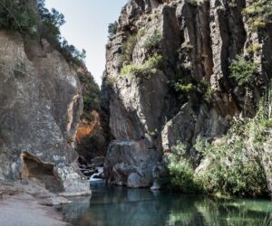
Sot de Chera is located 67 Km from the city of Valencia and 30 km from Requena, in the extreme south of the Serrania administrative region. Its steep streets are determined by a mountain range formed by large deformations of strata that make up the Sot Anticline. The village centre is crowned by a Muslim castle built on a promontory and declared of Cultural Interest (BIC). Other notable elements of its architectural heritage include the 17th-century church of San Sebastian Martyr, which has an altarpiece by the painter Juan de Juanes, and the 16th-century Renaissance Hermitage of Saint Roche. The municipality is crossed by the River Reatillo River, a tributary of the River Turia which originates the near Sot de Chera. As it crosses the village, the river creates a beautiful natural pool, known as “El Gruñidor”, in which visitors and villagers alike are able to cool off during hot, summer days.
-
Titaguas
The village sits on a gentle slope, sheltered from the north winds by a lush hill crested by “El Pico de la Lámpara”). The original centre, the Muslim hamlet, is located at the top of a slope in the area around Calle Calderona and Calle Cerrito. The 18th-century was a key period in its development. The expansion of agricultural and livestock activities, in conjunction with the privilege of being granted the consideration of a royal town of 1729, led to the construction of the main streets and squares, shaping the historical centre as we know it today, its configuration and unique elements reflecting the traits of traditional rural Valencian society. Agrarian economy linked to the cultivation of grain and vines, as well as sheep farming. In this context, some characters acquired a relevance that is expressed through their unique residences, as in the case of the “Casa de los Graneros” (Granary House). Barns, granaries and threshing grounds form streets and blocks on the outskirts of the village, on the both the Alpuente and the Tuejar roads. The threshing grounds, circular areas in which the threshing was carried out and which are surrounded by barns, form one of the most unique and valuable elements of the traditional local architecture. Titaguas’ caves are also noteworthy. These are often used as barns. This is the case of the cave of the Abbey House, in which the tithes were kept.
-
Tuejar
Tuejar is located in the administrative region of Los Serranos, set between beautiful valleys, rivers and mountains. This is a mountainous area with abundant pine forests and numerous natural springs, locations such as La Tartalona, 300m from Benagéber reservoir. It has a swimming pool, sports facilities, restaurant and campground; “El Azud”, located on the River Tuéjar, offers picnic areas, and “La Zagra”, which lies next to the River Turia, or “Blanco”, offers a swimming pool, services and camping area. The village has tourist infrastructure, accommodation, shops and services.
-
Villar del Arzobispo
Villar del Arzobispo is located approximately 50 km From Valencia. It is located in the administrative region of La Serrania, acting as a gateway to one of the most rugged but beautiful regions of the Valencia Region. This municipality has been populated since time immemorial and retains vestiges of all the cultures that have inhabited it through the ages. This is borne out by archaeological sites such as the Ibero-Roman settlements, wells, mills and monuments to be found in the village. It owes its name to the Romans, as Villar means “group of villas”. The Arabs would later name it Banaduf, which means “he who plays the tambourine”. The addition of “del Arzobispo” is due to the concession granted by King Charles IV, at the same time as he conferred upon the village the status of “Villa Real”. The Archbishop’s Palace was offered to the Emperor Charles V as a residence with a view to curing his illness, as he considered that Villar del Arzobispo was the “healthiest place in Spain”.

